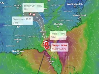
Hurricane Helene Live Tracker Map on Windy: Cyclonic Storm Hits Florida As Its Update to Category 4; Check Real-Time Status
By Lokmat English Desk | Updated: September 27, 2024 11:33 IST2024-09-27T11:15:38+5:302024-09-27T11:33:40+5:30
Cyclonic storm Helene made landfall in Florida on Thursday night (US Time), September 27, near the Big Bend coast ...

Hurricane Helene Live Tracker Map on Windy: Cyclonic Storm Hits Florida As Its Update to Category 4; Check Real-Time Status
Cyclonic storm Helene made landfall in Florida on Thursday night (US Time), September 27, near the Big Bend coast as it formed into a category 4 storm. The storm lash state with winds up to 140 mph, which led to several disasters.
More than a million Florida residents are without power as flooding and waterlogging were reported near the Tampa area. Houses were buried in knee-deep water. State officials have sounded an alert, urging residents to evacuate lowlying areas, which were also flooded with rainwater. A state of emergency has been declared in Florida, Georgia, South Carolina, and North Carolina.
Hurricane Helene Lands in Floria With Wind Speed of 130-150 Miles Per Hour
A video shared on X, formerly Twitter, shows Tampa General Hospital's AquaFence successfully keeping floodwaters at bay during Hurricane Helene. The hospital confirmed on X that the barrier is holding strong against the flooding water, designed to withstand up to 15 feet of water. With surge predictions reaching 20 feet in some areas, the AquaFence is crucial in protecting the region's only Level I trauma centre.
🚨🇺🇸TAMPA GENERAL HOSPITAL’S AQUAFENCE HOLDS BACK STORM SURGE FROM HURRICANE HELENE
— Mario Nawfal (@MarioNawfal) September 27, 2024
Video shows Tampa General Hospital's AquaFence successfully keeping floodwaters at bay during Hurricane Helene.
The hospital confirmed on X that the barrier is holding strong against the storm's… https://t.co/jhZkEEJ0Dnpic.twitter.com/iOe67UB4lJ
Hurricane Helene made landfall at around 11 PM ET as a Category 4 storm in the Big Bend region of Florida with winds speed of 140 mph. According to the latest update issued by the US National Hurricane Center (NHC), As of 1:00 AM EDT on Friday, September 27, 2024, the eyewall of the extremely dangerous Hurricane Helene has moved into Georgia, bringing catastrophic winds and a life-threatening situation to the region.
NHC has issued a dire warning for residents to remain in their shelters and not venture out as hazardous winds will quickly increase. Helene is currently located about 10 miles west-southwest of Valdosta, Georgia, and 55 miles northeast of Tallahassee, Florida. The storm is moving north-northeast at a speed of 26 mph, with maximum sustained winds of 110 mph and a minimum central pressure of 950 mb (28.05 inches).
1am EDT Friday Tropical Cyclone Update on #Hurricane#Helene:
— National Hurricane Center (@NHC_Atlantic) September 27, 2024
The eyewall is now entering southern #Georgia. Please do not leave your shelter & remain in place through the passage of these life-threatening conditions.https://t.co/XtkxtGDQLTpic.twitter.com/kA94pMbJZy
The impact of Hurricane Helene is already being felt in the region, with a WeatherSTEM site in southern Lowndes County, Georgia, reporting a wind gust of 88 mph (142 km/h). Another WeatherSTEM site in Kinderlou, Georgia, recorded a minimum pressure of 952.2 mb (28.11 inches) in the eye of the storm.
Hurricane Helene Live Tracker Map
Track the live map of Hurricane Helene on Windy.com to stay alert. Windy will show you the satellite view and real-time location updates on the cyclonic storm through its technology. Check the latest updates as Helene strikes the Big Bend in Florida and escalating at an alarming rate.
Meanwhile, a driver was killed when a signboard fell onto his car on Interstate 4 (I-4) in Tampa. This unfortunate death marks one of the first fatalities due to Helene, which has been wreaking havoc across Florida as it makes its way inland.
Open in app